Stop 1: Crater Lake National Park

Native Americans witnessed the formation of Crater Lake 7,700 years ago when a violent eruption triggered the collapse of Mount Mazama, a tall peak that was half a million years old. On the east side of Crater Lake, rocks that are 430,000 years old form Mount Scott. Pristine waters fed by rain and snow filled the caldera (Spanish for “kettle” or “boiler”), the deepest lake in the United States. Spend the day exploring the surrounding area, established as a US National Park in 1902.
Start at Rim Village, where you can take a self-guided tour, a walking tour of Kiser Studio, now the Rim Village Visitor Center, and the Crater Lake Natural History Association Bookstore. Immerse yourself in the interpretive panels at the nearby Sinnott Memorial Overlook. From there, take the Scenic Rim Drive around the lake, which offers views of the park’s volcanic formations. If you prefer to ride rather than drive the 33-mile Rim Drive, take a trolley tour that stops at the key overlooks. Rangers on board offer narration, trivia, and a dash of fun. Book ahead at www.craterlaketrolley.net.
Mazama Village is located just inside the south gate entrance, where you will find the Annie Creek Restaurant and Gift Shop, Mazama Village Camp Store, and Mazama Village Campground and Cabins. Eight daily boat tours to circumnavigate the caldera are on offer, plus two shuttles to Wizard Island. For a close-up view, take the Cleetwood Cove Trail, the only legal access to the shore of Crater Lake. This strenuous 2.2-mile round-trip hike begins at the East Rim Drive. Rim Village Visitor Center: Crater Lake National Park, Rim Dr, Oregon 97604, 541-594-3000
Stop 2: Mount Mazama

Before the most recent explosion, Mount Mazama loomed over the region. Today, all that remains is Pumice Castle, a remnant of the majestic ancient mountain. The towering rock formation, which juts out of the clear waters of Crater Lake, is composed of porous pumice and other volcanic materials that accumulated during Mount Mazama’s eruption and subsequent collapse. Seeing this unique geological marvel can be awe-inspiring as you contemplate the incredible forces of nature that created it. The brilliant white color of the rocks and the deep blue waters of Crater Lake create a striking visual contrast, and the castle’s reflection on the lake’s surface only adds to the scene’s beauty. The rock formation is accessible via a hiking trail, which allows you to get up close and personal with this natural wonder and provides stunning views of Crater Lake and the surrounding area.
Stop 3: Goosenest Mountain

Getting to Goosenest may be challenging since it lies on a rough logging road, which you may find gated, but the volcanic environment is unique. The Smithsonian Global Volcanism Program believes the volcano is at least 13,000 years old, having exploded last during the Pleistocene era. Lying to the north of Mount Shasta and prominently visible from Interstate 5, it is one of the region’s tallest and most scenic peaks. The lower elevations of the old shield volcano are blanketed in thick forest. The higher portions are a large cider cone with the entire western side covered by a massive lava flow. As the trail proceeds up, it becomes apparent that you are not climbing to the summit of the mountain but instead to the rim of a massive crater. When you reach the top, most of the prominent features in Siskiyou Count, including distant peaks, splay at your feet.
Stop 4: Lava Beds National Monument

Note: If you’re traveling from Goosenest to the Lava Beds National Monument, the road, although not on the Byway itself, is a bit primitive, requiring a high clearance 4WD vehicle. If you’re traveling between the two, you may want to choose an alternative route.
Lava Beds National Monument pays homage to the geological and historical turmoil this region has experienced over the past half-million years. Thanks to volcanic eruptions on the Medicine Lake shield volcano, the landscape is rugged, dotted with diverse volcanic features, and home to over 800 caves strewn about the high desert wilderness. Other highlights include Symbol Bridge and Big Painted Cave, Hidden Valley and Mammoth Crater, and Captain Jack’s Stronghold, the fortress of lava rock where the Modoc Indians stood for their homeland and refused to be relocated to a reservation. You can also learn about the Modoc War and the colorful characters like early cave explorer J.D. Howard and Prohibition-era moonshiners set up stills in the remote caves. You will find the largest concentration of lava tubes surrounding the monument headquarters.
Visitor Center: 1 Indian Well, Tulelake, CA 96134, 530-667-8113, Daily and year-round 10AM-4PM. Some roads are temporarily closed in winter due to snow.
The GPS-enabled audio tour can be found at:
https://voicemap.me/tour/klamath-county-oregon/the-modoc-war-a-homeland-lost
Stop 5: Crystal Ice Cave
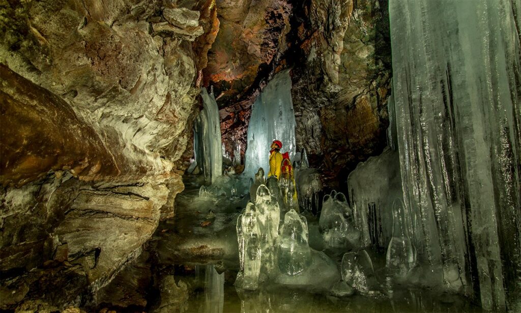
The spectacular ice formations in this cave are only accessible through a ranger-guided tour led by the staff at the Monument. Reservations can be made in advance. While observing the formations, some taller than a person, you’ll learn about the lava beds’ history and geology and why ice forms in some caves and not in others. Please do not try to access the cave yourself, as it remains locked when not being toured. If you want to explore other caves at the Monument, you need a Caving Permit before entering a cave. They are free and available at the visitor center. You also need the right equipment and explore responsibly. The following caves, best for beginning explorers, have relatively high ceilings and established trails or smooth floors: Mushpot, Valentine, Skull, Sentinel, Merrill Ice Cave, Heppe Ice Cave, Big Painted Cave, Symbol Bridge Cave, Ovis Cave, and Paradise Alleys.
Stop 6: Petroglyph Point

Also located within Lava Beds National Monument, explore Native American history through rock art and the archeological site at Petroglyph Point. This formation was created when volcanic tuff erupted from the floor of ancient Tule Lake to form an island. Waves undercut the cliff, and early people paddled out in boats to carve images into the soft rock. There is, in fact, more Native American rock art here than anywhere else in California. Modoc stories are still told about this unique and vital formation. Over the millenniums, weather has enlarged crevices that prairie falcons, great horned owls, and even Canada geese use as nesting sites.
Stop 7: Medicine Lake Highlands

The highlands areas around Medicine Lake include a volcano, a lake, a campground, and more. The large shield volcano, active for 500,000 years, stands nearly 4,000 feet above the surrounding plateau, with a total rise of almost 7,800 feet above sea level. Eruptions have been less explosive than other volcanoes, coating the sides with basalt lava. The Medicine Lake volcano is believed to be unique, having many small magma chambers rather than one large one. The region is dotted by numerous cinder cones, lava flows, and volcanic formations, creating a dramatic and otherworldly landscape.
Note: There is no driving access to the volcano’s highest point, and it is located on dirt roads.
Medicine Lake is part of the old caldera, a bowl-shaped depression in the mountain, in the crater of a collapsed volcano. The road to the picnic area on the east side of the lake is paved, and there are restrooms.
Medicine Campground is spread along the north shore of 640-acre Medicine Lake. As the crow flies, it is 10 miles southwest of Lava Beds National Monument. A forest of pine and fir surrounds the lake. There are 22 campsites for RVs, trailers, and tents. One campground loop is close to the lake, while the other is deeper among the trees.
Stop 8: Glass Mountain Obsidian Flow

Glass Mountain is a spectacular, nearly treeless, steep-sided rhyolite and dacite obsidian flow that erupted just outside the eastern caldera rim of the Medicine Lake Volcano and flowed down the steep eastern flank. Radiocarbon dating places the age at around 1,000 years old. The south side of the flow is accessible by road from the Medicine Lake area.
Stop 9: Rainbow Mountain

Note: The route to Rainbow Mountain is on logging roads that could be poorly signed and may be gated at times.
Rainbow Mountain, between Mount Shasta and the Medicine Lake Volcano, last erupted during the Pleistocene Age about 1 million years ago. The stratovolcano gets its name from the striking array of colors present in its rock formations. The vibrant hues are caused by various minerals, including iron, sulfur, and cinnabar, which have oxidized and created colorful streaks and patterns on the mountainside. There are lovely views of the area from the summit, but access is in a rugged, heavily forested area that could be difficult to access.
Stop 10: Pluto’s Cave
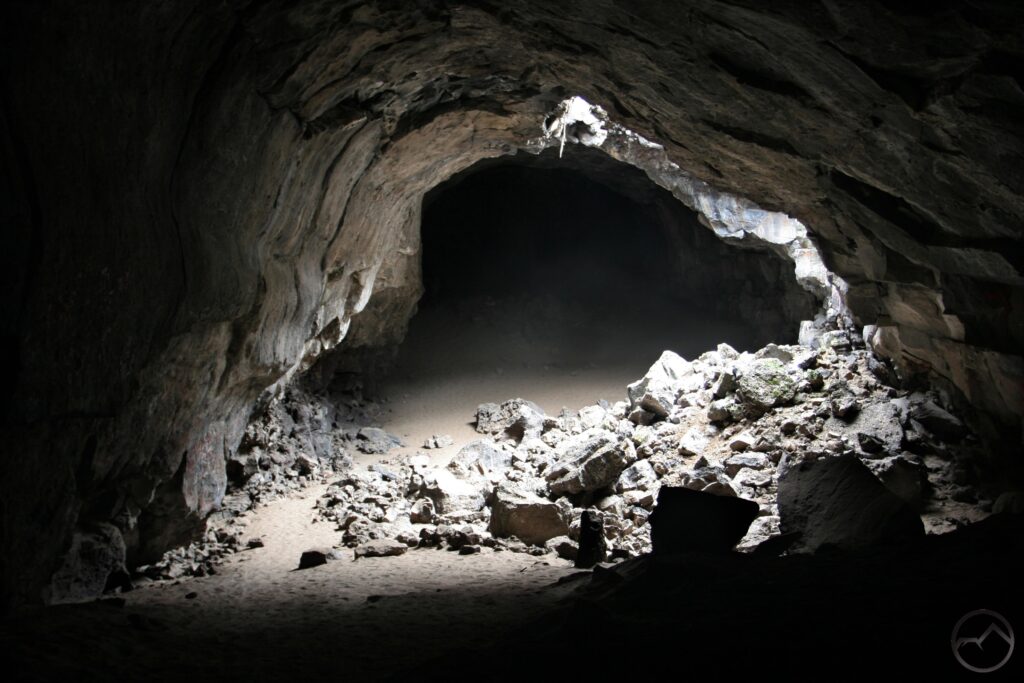
Note: Pluto’s Cave is a mile or two off Highway A-12, with a poorly marked turn-off. The last quarter of a mile to the cave is accessible by hiking. Visitors can safely hike about 1,200 feet into the cave.
Pluto’s Cave is a classic lava tube, a tunnel formed by molten lava passing through tubes in older, hardened lava. It was created by an eruption of basaltic lava which originated from a vent about 8 miles to the northeast, between Deer Mountain and The Whaleback, and served as one of the primary feeder tubes that carried most of the lava into the Shasta Valley. The small domes of lava at the main entrance, called schollendomes, were formed when the tube was filled with lava to the point where fluid pressure caused actual inflation of the flow, causing it to rise, bulge, and form the small domes.
You must take a short hike to the entrance to visit the cave. Once inside, you can explore numerous chambers and passages. It’s an opportunity to engage in physical activity and connect with the Earth’s geological history. The cave’s interior showcases various geological features, including lava formations, stalactites, and stalagmites. The diameter of this cave is substantial, with multiple lava flows visible in the cave walls of layered basalt, which is fine-grained at the base and coarse-textured and full of gas bubbles near the top. The “skylights” along the length of the cave were formed as the lava cooled and collapsed. The dark, otherworldly environment provides a sense of adventure and wonder as you witness the result of ancient volcanic activity.
Stop 11: Mount Shasta

Mount Shasta is a dormant volcano that consists of four overlapping, inactive volcanic cones. The fifth-highest peak in California, its pristine snowcap is visible year-round and provides the ideal backdrop for amateur and professional photographers alike. Geology enthusiasts can explore lava flows, cinder cones, and other volcanic formations in the region. There are also seven named glaciers on Mount Shasta – The Whitney Glacier (the longest in California) and Hotlum (the most voluminous).
The oldest-known humans settled on the mountain 7,000 years ago, including seven Native American tribes. The area has a powerful spiritual significance to these communities and is considered sacred by many indigenous tribes and various New Age communities. Some believe the mountain has mystical properties and serves as a spiritual vortex. Visitors often come seeking a sense of renewal and connection to nature.
The most efficient way to scale Mount Shasta, as far as you can drive up the mountain, is to drive the Everitt Memorial Highway, a two-lane, 14-mile scenic road up the southwest side. That can take less than an hour, or depending on what you do, it can take all day! The road is usually drivable from late June until late October when snow closes it above Bunny Flat.
The highway starts in Mount Shasta City but is only sporadically marked. Take Lake Street from the center of town, bend onto Chestnut, pass the high school, and you’ll be on your way. Or from the Mt. Shasta Ranger Station, drive east on Alma Street to the stop sign at Rockfellow Drive. Turn right and go one block to the stop sign at Everitt Memorial Highway.
You’ll find restrooms by the roadside at Bunny Flat and Panther Meadows, along with first-come campgrounds. Dogs are allowed on the Old Ski Bowl trails at the end of the highway and on Gray Butte Trail in the Panther Meadows area, but nowhere else in the Mount Shasta Wilderness. If you’re climbing the majestic 14,161-foot volcanic cone that dominates the landscape for miles around, “Panther Meadows,” “Bunny Flat,” and “Old Ski Bowl” are all great starting points for routes to the summit.
Stop 12: Black Butte

Rising sharply from the surrounding flat landscape, Black Butte stands as a sentinel overlooking the scenic Cascade Range and the nearby Deschutes National Forest. The steep, nearly treeless hornblende andesite dome formed about 10,000 years ago. After a large crater first developed at the base of Mt. Shasta, very thick magma began to issue from the crater. Four successive eruptions of material with the consistency of cookie dough were forced above the crater rim. As the flow cooled, internal stress caused the lava to break into chunks that rolled down the side of the dome. Remnants of the solid core can be seen as crags near the summit.
Climbing the 2.5-mile trail from the trailhead to the 6,325-foot summit of Black Butte delivers spectacular views of the surrounding area along the route. The course is moderately strenuous, winding its way up the volcanic cone through dense ponderosa pine forests and Douglas fir. Once you reach the summit, Mt. Shasta towers to the east, and the city of Mt. Shasta and the Sacramento River Canyon are to the south. Mt. Eddy and the Klamath Mountains are to the west. The town of Weed, the Shasta Valley, and Mt. Mclaughlin in Oregon are to the north. The trail surface is extremely rocky and steep in places, and no water is available. In good weather, it’s about a 2-hour climb.
Note: The trailhead to Black Butte turns off from Everitt Memorial Highway onto dirt roads. The route to the trailhead is not well-signed. Parking at the trailhead is minimal. Park off the access road and turn around the loop. The route is not recommended for buses or vehicles pulling trailers. A high-clearance 4WD vehicle is recommended.
Stop 13: Castle Crags State Park

While the Northern Coast Ranges of northwestern California consist primarily of rocks of volcanic and sedimentary origin, granite bodies (plutons) intruded many parts of the area during the Jurassic period. Heavy glaciation at Castle Crags eroded much of the softer rock, exposing the towering crags and spires that lend their name to the state park.
Visiting Castle Crags feels much like stepping into a landscape painting. As you hike along the trails, the towering formations starkly contrast with the lush green of the trees. The whisper of the wind through the pines and the distant calls of birds provide a tranquil soundtrack for your trek. As you gaze up at the crags, allow yourself to feel the power of nature that carved such magnificent rocks over time. The sight of Mount Shasta, often snow-capped and looming in the distance, will add to the sense of wonder. For those interested in history, the park offers a rich tapestry of stories that showcase the deep connection between humans and the land.
Situated along an ancient Native American trade route, the area witnessed the 1855 Battle of Castle Crags between area tribes and Gold Rush prospectors. The Castle Crags Wilderness features are considered sacred to Native Americans, including the streams, the Sacramento River, and the region’s abundant natural springs.
Stop 14: McArthur-Burney Falls Memorial State Park

Lush forests and an array of wildlife surround the 129-foot National Natural Landmark Burney Falls. The water comes from underground springs above the falls, providing an almost constant flow rate of 379 million liters daily, even during the dry summer. Being at McArthur-Burney Falls Memorial State Park reminds you of the magic of nature – from the roaring power of Burney Falls to the tranquil beauty of Lake Britton. Every corner of the park seems to have its own story, whether it’s a centuries-old pine tree or a playful squirrel darting about. The mix of aquatic beauty, dense forests, and diverse wildlife makes the park a haven for nature lovers.
Three main hiking trails get you right up close. Called “the Eighth Wonder of the World” by President Theodore Roosevelt, the falls are “at their most intense during the spring, from early April through October, when snowmelt is at its peak. National Geographic declared the site to be one of “northern California’s most spectacular waterfalls.
Stop 15: Hat Creek Lava Flows

The second largest deposits of lava in California, after Lava Beds National Monument, are found just north of Lassen Volcanic National Park. The black, jagged, mostly treeless expanse stretches over 20 miles along Hat Creek and features cinder cones, lava tubes, and small craters. The US Forest Service has developed two sites near the town of Old Station, on either side of Highway 89-44 junction. The Spatter Cone area is reached via a 1.7-mile loop trail that takes you past several craters, cave entrances, and fissures.
Stop 16: Subway Cave
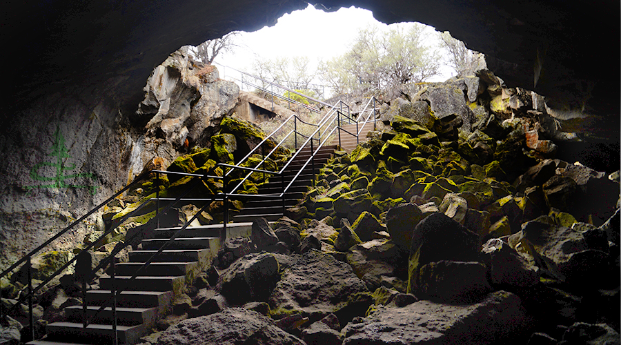
Subway Cave, located on a side road just north of the Highway 89-44 junction, is the most visited location in the Hat Creek area. A brief walk leads to the cave entrance, with steps making an easy descent to the cave floor. The walkable portion of the cave is about a quarter of a mile. Two short branch trails join in a large central chamber. The roof is smooth with small lavacicles where lava dripped slowly before cooling down. The first sensation is the enveloping silence, punctuated only by the distant drips of water and the muffled footsteps of fellow explorers. The walls of the tube glisten with moisture, and the cooled lava’s texture is rough and sinuous, bearing the imprints of its molten past. The ground is uneven in places, shaped by the turbulent flow of lava that once surged through this very tube. The cave narrows and opens into larger chambers as you make your way deeper. In certain areas, the ceiling has collapsed, creating natural skylights that allow slender beams of sunlight to penetrate the darkness, casting ethereal patterns on the cave floor. Throughout your exploration, it’s impossible not to reflect on the cave’s formation. Imagining the fiery lava streaming through, the heat, the glow, and the gradual cooling and solidifying process that led to this intricate subterranean wonder is awe-inspiring.
Stop 17: Lassen Volcanic National Park
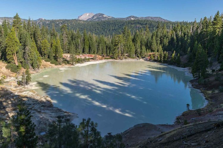
With steaming fumaroles, dazzling waterfalls, crystalline mountain lakes, bright wildflowers popping through verdant meadows, and over 50 volcanoes, Lassen Volcanic National Park is a jewel at the southern end of the Cascade Range. Lassen Peak first erupted in 1914 and continued a series of sporadic and powerful blasts over the next seven years, with the most powerful explosion in 1915. The following year, President Theodore Roosevelt combined two separate national monuments to create Lassen Volcanic National Park and named it after Peter Lassen, an early settler and trail guide. All four types of volcanoes that exist in the world can be found in the park – composite/stratovolcanoes, shield volcanoes, plug domes, and cinder cones, but the Lassen Peak itself is a large, 27,000-year-old plug dome that stands at 10,475 feet. Visitors can explore this and other volcanoes in the park on hikes to peaks like Chaos Crags, Brokeoff Mountain, and Cinder Cone. Other park highlights include the variety of volcanic hydrothermal features that can be spotted throughout the area. Find thumping mud pots, bubbling pools, steaming ground, and roiling fumaroles at Sulphur Works, Bumpass Hell, Devils Kitchen, Boiling Springs Lake, and Terminal Geyser.
38050 Highway 36 East, Mineral, CA 96063, $15 per car.
Lassen Volcanic National Park Highway
California State Route 89, a 30-mile recreational pleasure drive winding around the east side of Lassen Peak, offers an incredible drive to convenient access to the park’s most dramatic attractions. The drive, which takes about an hour without stops, begins at the junction of Route 36 and Route 89 on the southwest side of the Lassen Volcanic National Park and connects to the park’s northwest entrance.
Stop 18: Chaos Crags and Jumbles

This jumbled rockfall deposit occurred around 340 years ago when one of the domes collapsed in three cold rockfall avalanches on Lassen Peak. As the material moved down the slope, the mass of rock and debris from Chaos Crags was cushioned underneath by a pocket of air, causing the debris to flow more than 400 feet up Table Mountain on the opposite side of the valley from Chaos Crags. As you wend your way through the Jumbles, the sheer scale of the rockfall becomes evident. Boulders, some as large as houses, are scattered haphazardly, bearing silent testimony to the force of the event. Stepping between these massive stones, you can feel the weight of time and the raw power of nature. The ground underfoot is uneven, and every so often, you stumble upon pockets where nature has begun to reclaim the landscape, with small plants and shrubs sprouting between the rocks. Chaos Crags and Jumbles is an exploration of geology in motion, an intimate encounter with the Earth’s dynamic processes, and a humbling experience of the majesty and might of nature.
Stop 19: Hot Rock
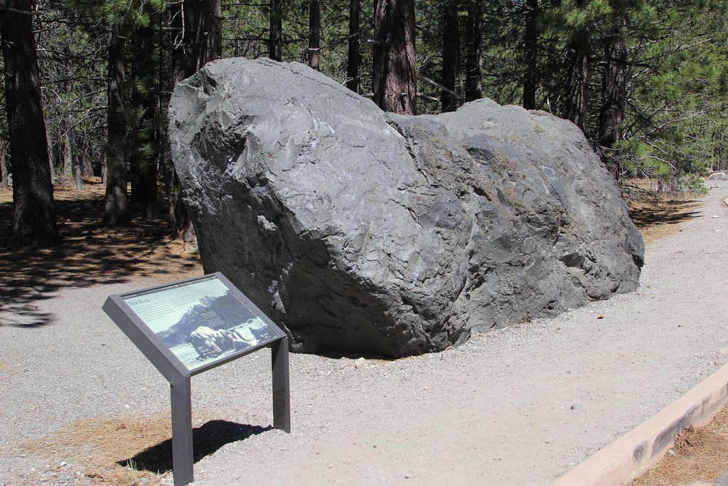
At rest for over 100 years in this location, the immense boulder was once in Lassen Peak’s vent. A violent lahar, or mudflow, carried this 30-ton rock, speeding down the peak’s slopes in a slurry of mud, earth, and rock. Visitors to the altered landscape reported that the stone was hot to the touch even months after the eruption since the internal temperature was estimated to have been 1000°F when it came tumbling down. Benjamin F. Loomis (Lassen Volcanic National Park features the Loomis Museum) captured photos of the 1915-1916 Lassen Peak eruption and a picture of Hot Rock after boiling mud mixed with ash and scattered rocks almost instantly transformed this area into a barren, inhospitable landscape. Find a nearby rock to sit on and take a moment to soak in the atmosphere. The warmth on your face, the sound of the earth breathing, and the vibrant colors around you are a sensory symphony. It’s a humbling experience, reminding you of the dynamic nature of our planet and the forces that continuously shape it.
Stop 20: Devastated Area

The name “Devastated Area” evokes images of destruction. As you make your way to this particular region of Lassen Volcanic National Park, there’s a palpable sense of curiosity and reverence for the power of nature. The well-marked trail takes you through a landscape that seems frozen in time. Interpretive signs tell the story of that fateful day when Lassen Peak erupted, sending a torrent of hot ash, gas, and rock racing down its slopes. As you walk, you come across remnants of trees, some still standing as charred and stripped skeletons, bearing witness to the explosion’s heat. While the initial scene may seem desolate, a closer look reveals nature’s indomitable spirit and resiliency. New trees are taking root, and vegetation is making a determined comeback. Birds sing from their perches, and the buzz of insects fills the air. In its infinite wisdom, nature is healing and transforming the scars of the past into a testament of resilience and renewal.
Stop 21: Cold Boiling Lake

The name “Cold Boiling Lake” seems paradoxical, and as you begin your trek to this peculiar destination within Lassen Volcanic National Park, a sense of wonder envelopes you. What sort of natural marvel could carry such a contradictory name? From a distance, it seems as if parts of the lake are boiling, with bubbles continuously rising to the surface. But, as you touch the water, you realize it’s cold. The “boiling” effect isn’t due to heat but to underwater gas vents releasing carbon dioxide into the cold water. It’s a surreal experience to witness what appears to be a boiling lake only to feel the chilly waters on your skin. The shores of Cold Boiling Lake are also teeming with life. Aquatic plants sway gently with the water’s currents, and you spot birds skimming the surface, occasionally diving to catch fish. The backdrop of the lake is a mosaic of green, with various trees and shrubs providing a vibrant contrast to the clear blue waters.
Note: There is no drive to the site, but one can park on the side of the road and hike in.
Stop 22: Lassen Peak
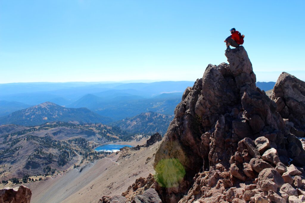
There is no drive up the peak, but reaching the summit on a two- to three-hour hike is possible. As the highest point in Lassen Volcanic National Park and the southernmost active volcano in the Cascade Range, ascending this mighty peak is both a challenge and a thrill. The only sounds as you hike are the crunch of your boots on the trail, the distant cries of raptors circling the skies, and the gentle whisper of the wind. It’s a symphony of nature, with each element playing its part in this grand orchestration. The final push to the peak requires determination. But as you summit to the peak, the feeling is euphoric. Standing at over 10,000 feet, the world stretches out before you. Rolling hills, shimmering lakes, and a mosaic of forests spread out in every direction. On the horizon, you can see the outlines of other Cascade Range peaks standing like sentinels in the distance. The journey back down is a time for reflection. With the gravity on your side, you make quicker progress, but the vistas and experiences of Lassen Peak stay with you. With its challenging terrain and breathtaking views, you’ll notice that your trek up the mountain and back has left an indelible mark on your heart.
Stop 23: Bumpass Hell

You’ve heard tales of Bumpass Hell, the largest hydrothermal area in Lassen Volcanic National Park. Named after an early settler who suffered a leg injury after falling into the boiling waters, this geothermal marvel beckons with tales of bubbling mud pots, hissing steam vents, and brilliantly colored mineral deposits. Beginning your trek, the trail unwinds gradually through dense forest, with birdsong accompanying each step. Soon, however, the verdant canopy starts to yield glimpses of the steaming basin ahead. As you draw nearer, the forest sounds are replaced by a unique symphony: the bubbling of boiling springs, the hissing of steam vents, and the murmurs of other visitors expressing their amazement. The scent of sulfur fills the air, a potent reminder of the volcanic forces beneath your feet. Treading carefully on the boardwalk, you pass by boiling springs, their surfaces disturbed by rising gas bubbles. Mud pots gurgle and splatter, their surfaces a dance of thick, bubbling earth. The ground itself is a tapestry of colors: whites, yellows, oranges, and reds, created by minerals like sulfur, iron, and quartz. Reflecting by the Springs: Finding a safe spot to sit and observe, you’re captivated by the stark beauty of Bumpass Hell. The contrast of the serene mountain backdrop with the chaotic, bubbling ground below creates a scene straight out of a science fiction tale. Yet, this is very real, a raw exhibition of Earth’s internal energies.
There is no drive to this astounding thermal area, but a hike from the parking lot will take one to the largest hydrothermal site in the park. The trail is open in the summer and fall only. The three-mile, round-trip hike is easy to moderate in difficulty.
Stop 24: Sulfur Works

Lassen Volcanic National Park is home to a myriad of geothermal wonders, and Sulphur Works is one of its most accessible and mesmerizing displays. Just a short distance from the park’s main road, this area offers a firsthand look into the geothermal activity bubbling beneath the Earth’s surface. Sulphur Works, located on the Park Highway, has long been a roadside attraction – an otherworldly place of vibrant colors, aromatic scents, and shifting ground that is both ancient and new. It is, in reality, a vent for the last rumblings of a long-dead volcano. Yet, it is reborn daily as forces of erosion and hydrothermal activity continuously alter the landscape. Although named after the chemical element of sulfur—a byproduct of the hydrothermal system—the area bears the British English spelling of the word assigned by a pioneer that once laid claim to what was then known as Supan’s Sulphur Works.
Stop 25: Brokeoff Mountain

Brokeoff Mountain, the imposing remnant of ancient Mount Tehama, offers a tantalizing glimpse into the past and panoramic vistas that sweep across the landscape of Lassen Volcanic National Park. Your journey to its summit will be one of both historical significance and natural wonder. The trek starts through a verdant, dense forest. Towering trees envelop the path, their branches filtering the sunlight, casting a pleasant, dappled shade. The air is cool and crisp, redolent with the scent of pine and damp earth. Every so often, a stream gurgles by, its waters clear and icy cold, hinting at snowmelt from higher altitudes. Halfway through the hike, a moment of realization hits. You’re walking on the remnants of what was once one of the most prominent peaks in California. Mount Tehama’s past eruptions and subsequent erosion have reshaped the landscape, leaving behind Brokeoff and a few other peaks as reminders of its former grandeur.
Brokeoff’s summit draws nearer, and the trail becomes steeper, challenging your endurance. But the promise of panoramic views drives you forward. Every drop of sweat, every labored breath, feels worth it. Standing at over 9,000 feet, the summit of Brokeoff Mountain offers a 360-degree panorama. From this vantage point, the remnants of Mount Tehama’s caldera are clearly visible. The breathtaking scene is complete with Lassen Peak, the park’s other titans, and the vast forests stretching to the horizon. The wind at this altitude carries a chill, but the sense of accomplishment warms your spirit.
Stop 26: Devil’s Kitchen

Devil’s Kitchen is Lassen’s second largest hydrothermal area, reached by a trail that begins at the Warner Valley trailhead. A series of rises and dips takes the trail through two seasonal stream crossings before the track rises a last time to the rim of Devil’s Kitchen. Wander among the crackled yellow and red mounds of the kitchen where steam whirls from fiery cracks in the ground, sounds of plopping, hissing, and belching fill your ears, and the smell of “something” cooking lingers in the air.
A well-maintained boardwalk allows you to navigate this volatile terrain safely. Each step offers a new perspective on the geothermal wonders below. There’s a sense of awe as you tread carefully, keenly aware of the raw energy seething just beneath the surface. The sounds at Devil’s Kitchen are just as mesmerizing as the sights. The constant hiss of steam vents, the burbling of mud pots, and the occasional deeper rumble from beneath the Earth create an auditory experience that complements the visual splendor. There’s a moment of profound realization as you pause by one of the larger boiling springs, watching as the water churns and bubbles. This isn’t just a spectacle to be observed; it’s a tangible connection to the volatile forces that shaped and continue to shape our planet. It’s nature in one of its rawest forms.
